The small Asenema waterfall:
Our next goal after the Aburi Gardens is the Asenema Falls in the Akuapem Hills, 25 km north of Aburi as the crow flies. 25 km that we take an hour to go.
Once near the site we ask a nearby service station permission to park Gandalf before joining the falls by a path of a few hundred meters. We meet a little before reaching the falls a local delegation in recognition to organize a festival in early August at the foot of the waterfall. We exchange a few words before continuing our journey.
These are very pretty falls just 5 minutes walk from the main road. It is truly surprising that they are virtually completely ignored by tourists. This is not one of our guidebooks who brought us here but just the geocache that should have been there (one of the reason why we love geocaching).


Apart from taking some pictures and admiring the falls there is not much to do on the site. We stay there only fifteen minutes before returning to the motorhome. We only walked a kilometer and a half but that's enough for us. The heat and humidity are second to none to stifle our energy.
Camping on the Volta River shore:
After this nicee waterfall we resume, without waiting, the road towards the Volta. We plan to spend one or two nights in a camp on the river. As the crow flies we are only thirty kilometers away from the camp but it will take us more than an hour and a half to get there. The road itself is not bad but it is an almost uninterrupted succession of villages and agglomerations that we have to cross at very low speed. It's really very painful.
The "Aylos Bay Garden" camp is 500 m north of the Atimpoku bridge on the Volta.
 |
| Atimpoku bridge over the Volta river |
We arrive at 17:25. We sit on the terrace above the river in the shade of majestic mango trees. We went down to about twenty meters altitude. It is again unpleasantly hot and humid. On the other hand the frame above the Volta is idyllic.
The temperature drops only very slowly. It is still almost 30 ° C in the car when I go to bed around 22:00. I dare to hope that the Volta will help bring down the temperatures during the night.
The Volta is a little more than 300 m wide at our level but the flow is almost zero, it looks more like a lake than like a river.
 |
| Gandalf at "Aylos Bay Garden" |


It is indeed regulated by the Akasombo dam 8 km upstream. This dam was built between 1961 and 1965 to provide the country with electricity, particularly that of the Tema aluminum smelter. This dam is at the origin of the creation of the largest artificial lake in the world, Lake Volta.
Kulugu Trail and Mountain Paradise Lodge in The Volta Mountains.
The road to reach our next goal is not the best. Very good on some sections and catastrophic on others.

We arrive at Fume where we take an excellent mountain road which leads us through a series of hairpin bends in 4 kilometers to our goal: the Mountain Paradise Lodge at the end of a 200 m track on the left.
We settle at the foot of a pretty mango tree. This lodge offers rooms (8 in all) but it is also possible to camp for 20 cedis per person per night. It is beautifully situated at the top of a hillock above the Kulugu River.
 |
| Gandal at the "Mountain Paradise Lodge" |


We inquire immediately on the possibilities of excursions in the surroundings. The manager, a young Beninese woman who answers to the name of Victoria, explains to us on a map the Waterfalls Trail which can be done with a guide or alone for 20 cedis per person.

The start of the trail in a hairpin of the road is very well indicated by a white arrow. It is well cleared and fairly easy to follow despite the fairly steep slope that leads us to the bottom of the valley. After 150 meters a small hook of thirty meters leads us to the first waterfalls. In fact it looks more like powerful rapids than a waterfall. According to the map provided by the Lodge it would be possible to swim in the natural pools that the Kulugu has dug here. It must be true in the dry season but this morning after the storms of the night the current is really too strong to think about dipping here.


We go back to join the main trail which itself will take up quite a lot of altitude in the dense vegetation on the side of the valley. A vegetation that protects us completely from the wind, which combined with the high humidity and the relatively high temperature makes us sweat in big drops in the climb. It's really far from pleasant.
After a short break on the big pebbles of the trail we soon arrive at the main point of interest of the hike, the Kulugu waterfall. Its access is not easy by a path that descends steeply and ends with a dozen meters vertically in the rocks. A strong rope was placed there to help us abseil.


It is a fall of a small fifteen meters high that crashes into a beautiful natural pool before rushing into a narrow canyon. Here too it should be possible to bathe, but what is valid for the first fall of a while ago is even more for this one. No need to think about it with the violent current. We would have liked to have our snack break here but we must be disappointed, all the surroundings are much too wet and it is impossible to find a dry place to put our buttocks there.
We ascend again with the help of the rope to join the main trail. We move carefully because the path is narrow along the walls of the valley. A good hundred meters later it ends on the banks of the torrent that should cross at this point. After a little hesitation I take off my shoes to test the ground. The torrent is decidedly too deep, I already have water above the knee only a few inches from the bank. Having no idea of the depth in the middle and given the violence of the current we decide to turn around and return to the camp by the way by which we arrived. No need to take unnecessary risks
Mount Gemi, 800 m.
This morning the sky is very cloudy and very low, the village of Amedzofe at the top of the hill opposite us on the other side of the valley remains invisible in the clouds. It is the same with Mount Gemi above the village, our goal of the day.
A little after 13:30 the sky seems to want to emerge. Amedzofe and Mount Gemi are again visible in front of us.
Amedzofe is the highest locality in Ghana at about 700 m altitude. We are there at around 2:45 pm after asking where was the tourist information center. Driving to Amedzofe is not easy because the streets are not paved. They are difficult to drive because ravaged by rainwater.
Arrived at the tourist information center we follow the instructions of the natives to park Gandalf at the foot of a pretty mango tree at about thirty meters from the center.
 |
| Gandalf parked "downtown" in Amedzofe |
The village is not big and we find ourselves in a few tens of meters on the trail that climbs to the top.
 |
| Amedzofe |
 |
| Beginning of the path to the summit |
Destiny leads us to the edge of the hill for a short break. From here the view is vast towards the west, we even guess Lake Volta on the horizon. And then we enjoy a beautiful view overlooking the Mountain Paradise Lodge. We stay a dozen minutes because not only the view is superb but it blows a nice refreshing breeze, almost permanently after Destiny, so he loves to come and relax on these rocks.
 |
| Break on the edge of the hill |


We finish climbing the last 40 meters of altitude to the summit at 790 m where we will enjoy the panoramic view that extends from the mountains of the east to Togo to the plain of Lake Volta to the west. Mount Gemi and the second highest mountain in Ghana, the highest being Mount Afadjato 885 m further north. Here on the mountain we find only grass but all the surrounding reliefs are covered with a green carpet of tropical vegetation.
 |
| From the top |
 |
| At the top |

 |
| At the small market of Amedzofe |


The Wli Waterfall
Thirty kilometers to the north-east near the border with Togo is a nice camp: the Waterfall Lodge. This small tourist complex was created by a couple of Germans in 2003: Sabine and Bernhard, arrived in 2001 in Ghana. They were actually en route to South Africa and fell in love with the area they never left.
 |
| The bad road to Hohoe |
 |
| The Waterfall Lodge at Wli |
We settle in the small meadow slightly below the entrance.Beyond the grassy area where we are installed Sabine maintains a beautiful exotic garden on nearly 2000 m2. She will make us visit by giving us many explanations on the virtues and properties of the different plants that she cultivates there.
 |
| Gandalf at the Waterfall Lodge |

The most interesting for us is the countless pineapple feet which she explains the reproduction. You should know that a pineapple foot needs 13 to 16 months to produce a ripe fruit. Reproduction is done by separating the daughter (rejection) from the mother. The daughteris bounced into the ground independently to live her own life.
 |
| Pineapple with rejection |
We present ourselves at the reception where, after we have registered in the register, we pay twice 20 cedis (3,53 €) for access to the park. Our guide will be Sebastian, although the ride does not require the services of a guide it is mandatory to have one, they explain. In general I prefer to walk without a guide but in Africa it gives work to the people of the village who need it. As anyway it is included in the price it does not change much!
The hike is indeed very easy in the rainforest. Sebastian shows us cocoa trees, avocados and even a coffee tree. He is quite surprised that we recognize the coffee, "how do you know? ". Sorry to have broken his effect !!
 |
| With Sebastian on the trail in the forest to the Wli Waterfall |
 |
| In front of a coffee tree |
 |
| Coffee beans |
 |
| Cocoa tree |
The trail follows more or less the bed of the Agumatsa River (meaning "let me flow" in Ewe). According to our maps and GoogleMap it is this river which is border between Togo and Ghana. But on the ground it does not look like it, we cross it nine times by small concrete bridges and apparently we do not change countries. In fact, Togo is on the other side of the mountains and cliffs and this area at the foot of the mountains is almost inaccessible from Togo. So we cross the border nine times before arriving at the falls.
 |
| Crossing the Agumatsa River from Togo to Ghana |
Oh, I almost forgot to say that Wli falls are the highest in West Africa. Higher than any we have seen so far, particularly in Guinea.
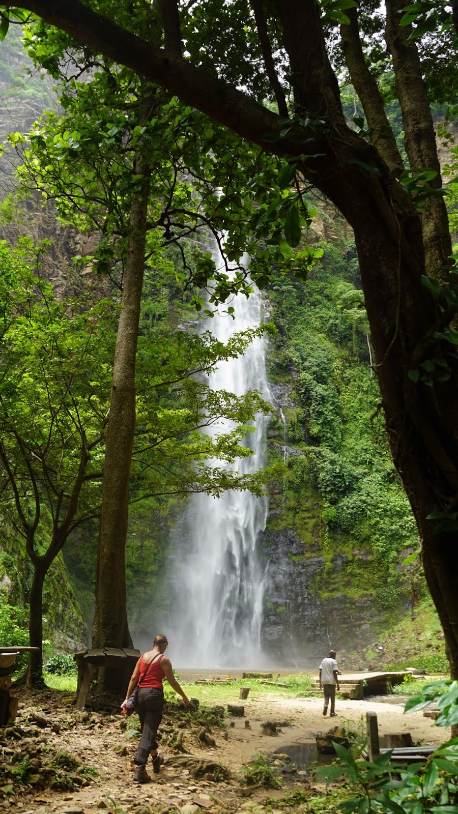 |
| The Wli Waterfall |


Sebastian points out to us the gigantic colony of bats nesting in the cliffs to the left of the falls. We did not notice them, but there are hundreds if not thousands. Awesome!
 |
| Bats |
 |
| View to the mountains and Togo from the lodge |

 |
| Sabine, Thierry and Bernhard |