2019-10-30/31:Pedras Negras, unexpected rock formations in the middle of the Angolan savannah.
First day
The road after N’Dalatando is excellent and relatively new. On the whole Angola makes a fairly good impression on us when it comes to infrastructure. The authorities do seem to be taking care of the upkeep and maintenance, although there is still a long way to go. The country needs to be completely rebuilt after the ravages of 30 years of civil war, even though the war has already ended for almost two decades. The fall in oil prices does not help matters.
 |
| The track to Pedras Negras. |
We take an hour to arrive at the small village of Quizenga at the end of which a good track goes to the right towards the “Pedras Negras” (the Black Rocks) towards the south. After 33 km covered in one hour we find the tar of the road coming from Cacuso. The famous Black Rocks that we had been focusing on for a good ten kilometers are now within reach. After 3 km we take the small tarmac road on the left which winds down towards the rocks. We follow it for 5 km to stop at the end of a bedrock 250 m from the road. It is here that one can observe footprints in the rock, footprints left according to legend by King Ngola Kiluanji and Queen Ginga, undoubtedly the most famous woman in Angolan history, strategist, warrior, negotiator and formidable manipulator.
 |
| The “Pedras Negras” in focus. |

 |
| A small road which threads its way between the rocks. |
 |
| Gandalf at the bivouac at the foot of the rocks. |
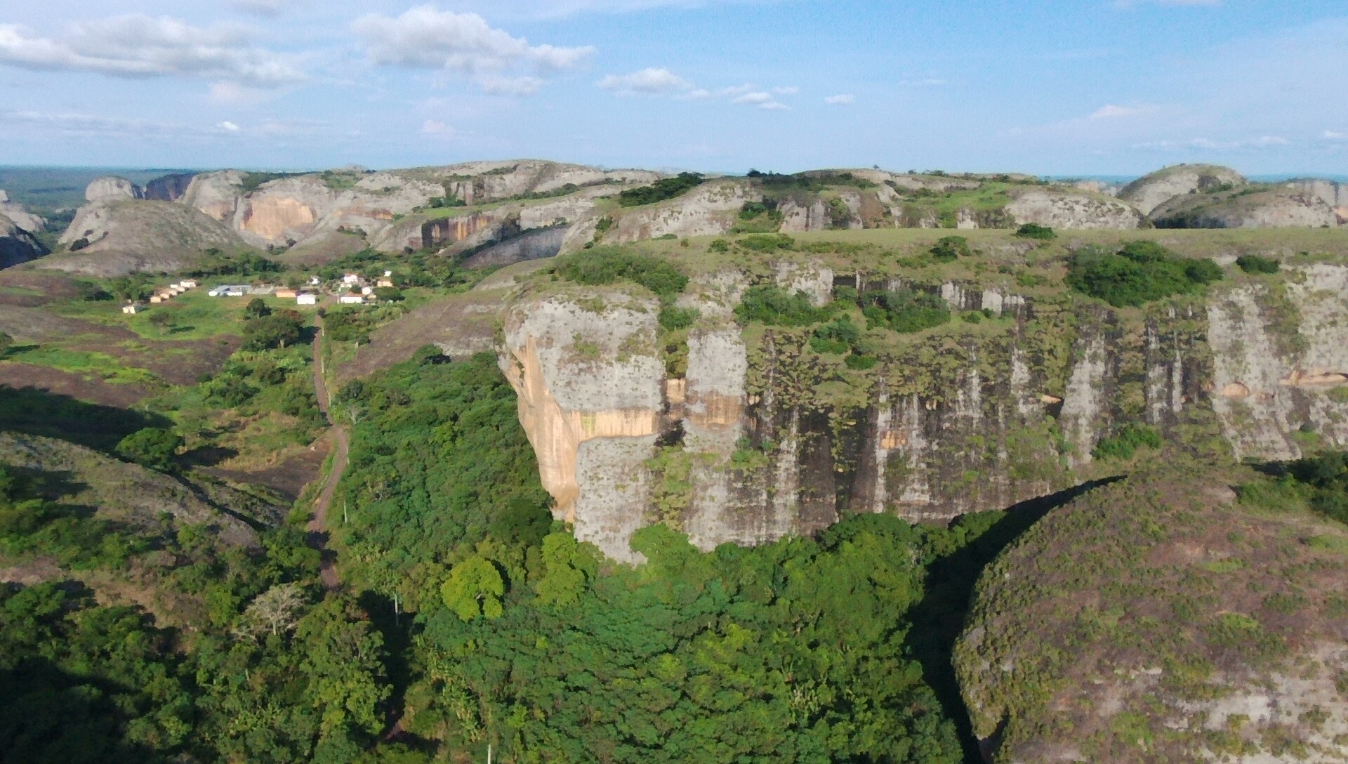
For geologists, these rocks, which cover a rectangular area of about 12 km by 6 km and rise up to more than 200 m above the surrounding savannah, represent an enigma because their composition (hard sedimentary conglomerates) is totally foreign to the region.
We walk a bit around in the immediate vicinity, including the famous footprints protected by small concrete constructions. Apart from the legends about the royal origins of his prints I can't find anything on the internet to explain their presence here.

 |
| Footprints in the rock. |
The opportunity is ripe, I will get my drone back on duty to explore and film the surroundings. Observed from an altitude of 150 m the site is truly impressive, the aerial views allow to capture the full extent of these rock formations.
Although this is one of Angola’s major tourist spots, we’re on our own. Five or six children appear to go for a bath with their mothers in the small stream below. A little later two couples of Angolan tourists approach me and worry about whether I filmed them with the drone bathing, apparently in the simplest form. I show them the videos on the computer, they are reassured and wish us a good day when they leave.
 |
| At the bivouac. |
It wasn't really planned at the beginning but we decide to stay here for the night, the area is really too nice!
The temperature cooled considerably in the evening, dropping to 23 ° C in the motorhome around 10 p.m. Christine is even forced to put on a small jacket. It had been a long time!
Second day:
 |
| Christine at the foot of the Pedras Negras at the bivouac. |
Today we decided to go to the end of the small road because we know that there starts a path towards a point of view not to be missed, it seems.
The road ends after barely five minutes with a cul-de-sac at the level of what looks like a village - with (disused) school, town hall, police station, church, sports field - which hardly seems inhabited by more. than a handful of villagers. We stop Gandalf in the large deserted square to take the path to the rocks on foot.
 |
| On the way to the panorama. |
 |
| Christine on the trail ... |
 |
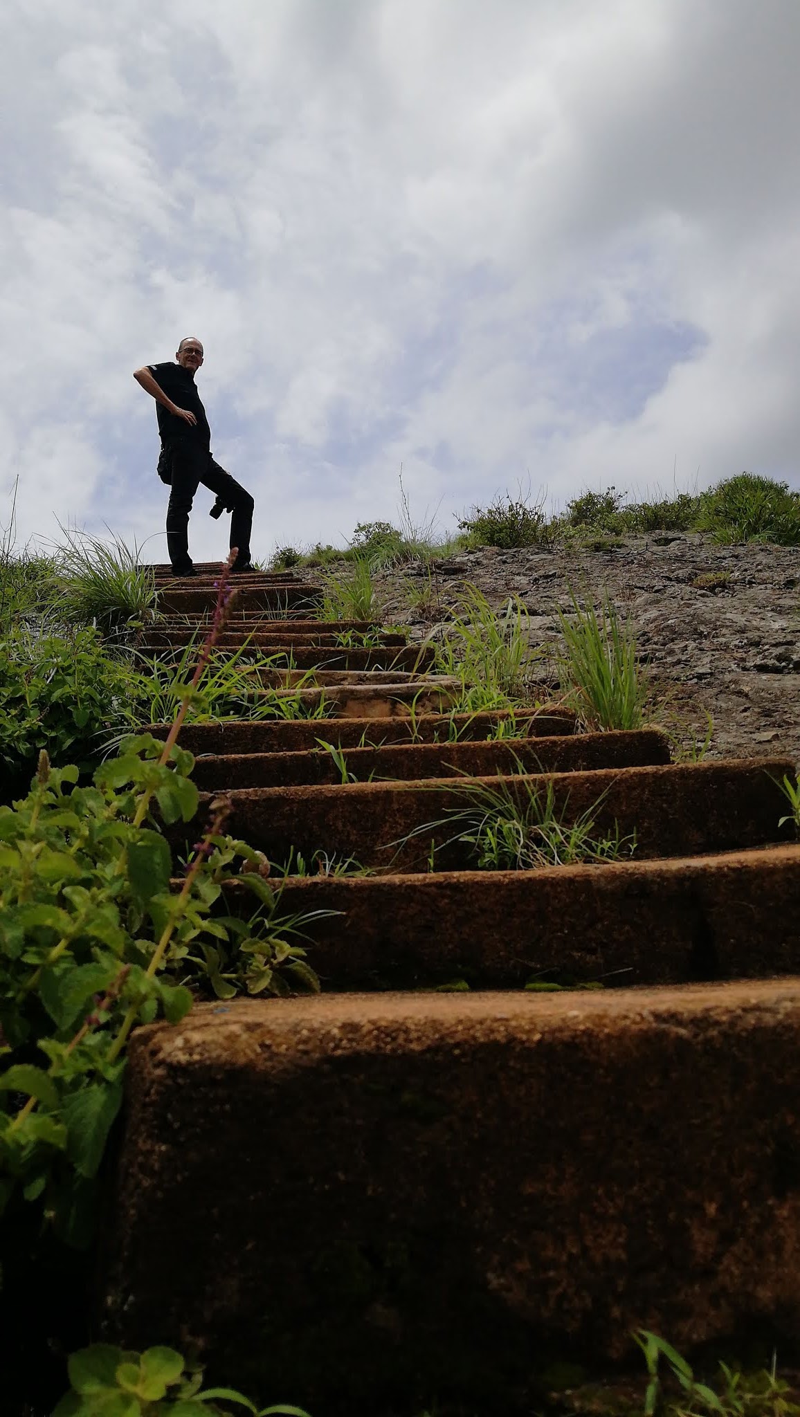
| ...and Thierry at the top of the stairs |
The path bypasses in 800 meters by the south the monolith on which we will go up by a series of steps. From up there the panorama is indeed impressive and we will spend half an hour admiring it in all directions, because it is really 360 °, from the reservoir of the Capanda dam on the Cuanza to the south. until the tangle of monoliths in other directions all around us.
 |
| Panorama to the south |

 |
| The rocks to the north-west. |
 |
View on the village
|
We are back in the "village" at noon but we do not join the motorhome. As a little wind tempers the heat of the sun, we decide to follow another path that penetrates deeply into the rocky landscape towards the east. We follow him for a little less than a kilometer and a half. It's a narrow path that winds its way through the thick underbrush through the rocks. We appreciate that it was recently cleared with a machete.
We are back around 1:00 p.m. We sweated a lot because the sun was strong in the middle of the day and the wind did not do its job as it should. We take advantage of a tap to cool off and rinse off before returning to the motorhome. Intrigued to see a small group of women coming back loaded with water cans by the path when there is a tap in the village, we ask them the question. Tap water is not drinkable. They get their drinking water from a well 200 meters away.
 |
| Tap water is not drinkable. |
 |
| The old abandoned school. |
 |
| The trace of our excursion within the Pedras Negras. |


Keine Kommentare:
Kommentar veröffentlichen